Help Files - Internet Map Server
These help documents have been compiled for the most commonly used functions in the internet map server. Click a link in the blue box on the right to access a help video.
Navigation Tools
Map Layers
Searching - Quick Find
Info, Measure, Print Tools
Tooltips
Map Views
Zoom Control
Markup Tools
 | Zoom In Operation: Click this tool on the tool bar and click once on the map. Result: The map will zoom in to approximately half of the current map scale. |
 | Zoom Out Operation: Click this tool on the tool bar and click once on the map. Result: The map will zoom out to approximately twice the current map scale. |
 | Zoom To Box Operation: Click this tool on the tool bar. Click once and hold on the map while dragging in a "down and to the right" motion. A box will begin to show as you draw. Release your mouse button. Result: The map will zoom in approximately to the box. |
 | Center Operation: Click this tool on the tool bar and click once on the map. Result: The map will re-center where you clicked. |
 | Zoom to Fit Operation: Click this tool on the tool bar. Result: The map will zoom out to the intial position, showing the entire city. |
Pan Tools Operation: Click one of the directional arrows. Result: The map view will move in the direction of the arrow that you clicked. | |
Map Layers (Top)
Layers Pane Operation: Click the round blue button on the right side of the layers pane when it is closed. Result: The layers pane will open. Operation: Click the round blue button on the right side of the layers pane when it is open. Result: The layers pane will close. | |
Layers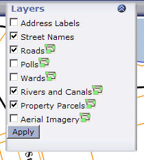 Operation: Check on or off the layers you want displayed and click the "apply" button. Result: The map will reload, with the layers on or off as you have selected. | |
Metadata Operation: Click the green icon next to the layer in the layers pane. Result: A new browser window will open, showing the metadata for that layer |
Searching - Quick Find (Top)
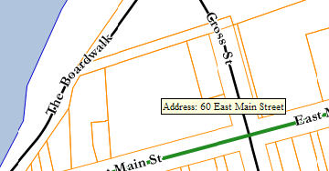
Quick Find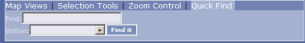 Operation: Enter a search term into the box labelled "Find:". Select what the search is within by selecting an item from the "Within:" drop-down list. Click the "Find it" button. Result: If any features are found matching your search term, the map will zoom to the objects and select them. The info window will also pop up showing the results of the search. Tips: When searching for an address, be as accurate as possible to begin with. For example, if searching for "60 East Main St", enter the address "60 East Main Street". If there are no results, then enter "60 East Main". If there are still no results, then try entering just the street name "East Main". |
Info, Measure, Print Tools (Top)
 | Info Operation: Click this tool on the tool bar and click once on the map on a feature that you want to see information for. Result: The info window will open showing the information for the feature you clicked on. Click the red "X" in the Info pane to un-select the object. 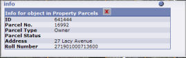
|
| Measure Line Operation: Click this tool on the tool bar and click once on the map. A green dot will appear where you clicked. This is the start point of your measure line. Click again somewhere else on the map. A green line will appear from the first point to the second. Continue clicking until your measure line is finished. Result: A small blue box at the bottom of the screen will appear displaying the length of the line. | |
| Measure Area Operation: Click this tool on the tool bar and click once on the map. A green dot will appear where you clicked. This is the start point of your measure polygon. Click again somewhere else on the map. A green line will appear from the first point to the second. Continue clicking until your measure polygon is finished. Result: A small blue box at the bottom of the screen will appear displaying the area and perimeter of of the polygon. | |
 | Clear Measure Operation: Click this tool on the tool bar. Result: All of the results of the measure tools will be cleared from the map. |
 | Print Current View Operation: Click this tool on the tool bar. Result: A new browser window will open showing the are to be printed. |
Tooltips (Top)
 Operation: Hold your mouse over an object on the map for a couple seconds. Result: If available, a small yellow window will pop up beside your mouse pointer with some quick info in it. Not all objects will have tooltips. Tip: If a tooltip does not appear after repeated attempts, your internet browser may be out of date. Ensure that you have the most updated version of your browser. You may need to download and install the latest version of the Microsoft XML parser. Click here to download. |
Map Views (Top)
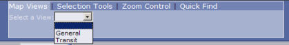 Operation: Select a different map view from the drop down list on the Map Views tab. Result: The map server will change to the new view that you have selected. Tip: If there is a view you need but it is not available in the list, contact us to set it up. |
Zoom Control (Top)
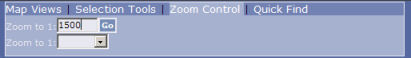 Operation: Enter a scale value in the "Zoom to 1:" box and press "Go", or select a preset scale from the drop down list. Result: The map will zoom to the new scale value, centred on the same location. |
Markup Tools (Top)
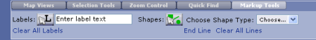
 | Add Label Operation: 1. Enter some text for the label in the input box. 2. Click the "Add Labels" button. 3. Click on the map where you want the label to be placed. Result: A label will be placed just to the right of where you clicked with the label text as entered. |
 | Add Lines Operation: 1. From the drop down menu "Choose Shape Type" select "Line". 2. Click the "Add Shapes" button. 3. Click on the map to add the starting point of the line (a green dot will be displayed). 4. Click again at another location to add a point to the line (a green line will be displayed). 5. You can continue clicking to add points to the line. When you are finished with this line, click "End Line" on the Markup Tools tab. The line will turn red, indicating that it has been added to the map. Result: A line will be added to the map. |
Help Videos
|
